


Purchase Tickets
Mapping Indiana
January 13, 2016
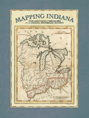
Mapping Indiana: Five Centuries of Treasures from the Indiana Historical Society is the most recent publication from IHS Press and is endorsed by the Indiana Bicentennial Commission. It is a 10-pound, 320-page, hand-stitched, full-color marriage of information and beauty. Forgive the flight of fancy, but this is truly one of the most beautiful books I have ever seen. I?m not naturally a cartophile or map lover but this book may have changed that. Each of the more than 100 maps is accompanied by an explanatory essay and many include enhanced views focusing on different parts of the map.
Below is a brief Q&A with two of the coauthors, Eric Mundell and Amy Vedra. Mundell is the director of collections management and Vedra is the director of reference services at the Indiana Historical Society.
How did the idea for the book come about?
EM and AV: The seed was planted in the 1990s and was the brainchild of former library staff. At that point in time, very few of the maps were cataloged and access was chiefly coordinated with the curator. Since the Indiana Historical Society has a long history of publishing, I believe it was a natural evolution in thought that a book could highlight the collection nicely and be an attribute to IHS and to its mission.
Are the maps in the book the entirety of IHS?s map holdings? If not, how did you choose?
EM: By no means. The book represents less than ten percent of the total map holdings of the William Henry Smith Memorial Library. Selection was arduous. Following a core set of criteria, a pan-institutional committee was assembled for initial selection among a broad spectrum of subject material. The co-authors were then charged with refining or enhancing coverage topically in specific areas. Other additions were made, organically, as the project evolved.
AV: IHS has more than 1,700 cataloged maps in its collection. With just over 100 maps highlighted, it was definitely difficult to choose what maps to include and unfortunately that means many gems in the collection had to be passed over. However, those that didn’t make the cut are available for viewing by library patrons.
What is the oldest map in the collection or book?
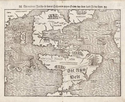
EM and AV: To our knowledge, the oldest map is Sebastian Munster’s Die neuwen Inseln, so hinder Hispanien gegen Orient, bey dem Landt Indie ligen, being the earliest known separate map of the Americas. It dates as early as 1540 or as late as 1578. We also have a large number of maps appearing in the 11-volume atlas set produced by Dutch cartographer Joan Blaeu in 1662. It is a truly amazing source. [Geographia, quae est cosmographiae Blavianae pars prima (-quinta) qua orbis terrae tabulis ante oculos ponitur et descriptionibus illustratur, 1662.]
What is your personal favorite map and why?
EM: I favor the specialty maps and those depicting the American colonies and the Early Republic. Italian cartographers, like Vicenzo Coronelli and Antonio Zatta, were especially adept with their artistry and intriguing detail. Picking a favorite often presents me with a “Sofie’s Choice” sort of scenario. If I had to choose, it probably would be Thomas Hutchins?s Carte des environs du Fort Pitt et de la Nouvelle Province Indiana : dediee a M. Franklin [1778], with the rationale that it likely shows us the first documented use of the name Indiana on a published map. That reference was to a large plot of
land now in West Virginia that had little to do with the Hoosier state.
AV: The M_nster map, as we call it, is my favorite map for many reasons. It is widely believed to be the first representation of the North and South American continents connected by a land bridge. It is also likely the oldest printed item in our collections, dating between 1540 and 1578. Plus getting to see 16th-century paper is just cool, and, to top it all off, it’s in great condition for something that is more than 400 years old!
How long did this project take writing, researching, editing, designing, etc.?
EM: The project saw many starts and stops through the years. It was reinvigorated with a second impetus in 2006 and 2007. The research, documentation, writing and initial editing phase was steady through February 2009, when all written work was submitted, and then the team of editors from the Press took over. Design probably encompassed another six months after that. With the ups and downs of progress and scheduling over time, we tend to say that book was over a decade in the making.
AV: Maps and essays were chosen and begun as early as 2006, though much more thought and work went into the project before it officially began. With a few pauses for a variety of reasons, this work was a labor of love for more than a decade!
Mapping Indiana: Five Centuries of Treasures from the Indiana Historical Society is available at the Basile History Market in the Eugene and Marilyn Glick Indiana History Center or call (317) 234-0020.
$59.95, 13 inches by 17 inches, color
Don’t forget to visit us for the Mapping Indiana exhibit in the Rosemary McKee Lanham Gallery, Jan. 16 through April 2.
__________________________


Drop us a line
Let's talk
Full Staff DirectoryOur Hours
ExhibitsOpen 10 a.m. to 5 p.m. Tuesday through SaturdayOpen 12 p.m. to 5 p.m. SundayWilliam H. Smith Memorial LibraryOpen 10 a.m. to 5 p.m. Tuesday through Saturday
Open 12 p.m. to 5 p.m. SundayHistory MarketOpen 10 a.m. to 5 p.m. Tuesday through Saturday
Open 12 p.m. to 5 p.m. SundayStardust Terrace Café HoursOpen 10 a.m. to 2 p.m. Tuesday through Saturday
Open 12 p.m. to 3 p.m. Sunday